112: Lessons from the Mount St Helens Volcano Eruption


Podcast: Play in new window | Download
May 18, 1980, is a day that many Pacific Northwesterners will never forget – it was the day the Mount St Helens volcano erupted. The Mount St Helens volcano is located about 100 miles south of Seattle and 50 miles northeast of Portland, Oregon.
The eruption of the Mount St Helens volcano was the most destructive in theUnited States’ history.
Why Is Information About the Mount St Helens Volcano Eruption Helpful for Preparedness?
Hopefully, you don’t ever have to experience the eruption of a volcano. However, understanding the science behind it can be helpful.
It’s good to know on some level how rocks form and how nature happens around us. That way, when you’re driving around – perhaps you’re out in the desert, or maybe you’re in the mountains – you know enough about what you’re looking at to realize that might be a dangerous thing.
According to the USGS, volcanic ash was detected in cities in the central United States on the day of the eruption. Two days later, residents of cities in the Northeastern United States noticed it, and within two weeks, the ash had spread around the globe.
The Eruption of the Mount St. Helens Volcano
As mentioned above, on May 18th, 1980, Mount St. Helens volcano erupted. Mount St Helens is in the Cascade Mountain range along with Mt. Rainier, Mount Hood, and a bunch of other volcanoes up there.
When the eruption happened, it resulted in the deaths of 57 people, along with the destruction of about 250 homes, nearly 50 bridges, and hundreds of miles of roads. Most of those who died passed away of asphyxiation when they inhaled hot volcanic ash, while some victims died from thermal and other injuries. The furthest victim of the eruption was discovered 13 miles away.
The lateral blast, debris avalanche, mudflows, and flooding caused extensive damage to land and civil works. All buildings and related manmade structures in the vicinity of Spirit Lake were buried. More than 200 houses and cabins were destroyed and many more were damaged in Skamania and Cowlitz Counties, leaving many people homeless. Many tens of thousands of acres of prime forest, as well as recreational sites, bridges, roads, and trails, were destroyed or heavily damaged. More than 185 miles of highways and roads and 15 miles of railways were destroyed or extensively damaged.
Some bodies were never recovered because that gigantic wall of mud, boiling water, lava, and debris comes barreling down the side of the mountain at hundreds of miles per hour. It doesn’t leave a whole lot left in its trace.
The Mount St. Helens volcano is less than 40,000 years old, and the cone that blew in 1980 took over 2000 years to build. The USGS ranks Mount St. Helen’s as the second most dangerous volcano in the United States.
Geology & Tectonics
The Mount St Helens volcano is a large cone consisting of layers of lava rock, ash, and other deposits.
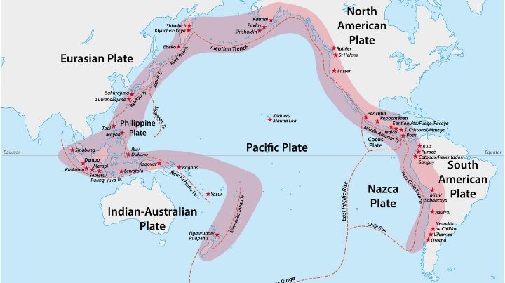
Mount St Helens is part of the Cascade Mountain Range, which is on the edge of the Cascadia subduction zone of the Juan de Fuca and North American tectonic plates. A subduction zone is where one tectonic plate rides up over another.
The Cascade Mountain Range is part of the Ring of Fire known as the Cascade Arc, consisting of 160 volcanos. Yes, there are 160 volcanoes in that little volatile corner of North America.
The Ring of Fire rises out of the Pacific Ocean floor, where the Juan de Fuca Ridge lifts up out of the seafloor. The ocean floor that spreads to the east of the Juan de Fuca Ridge is the Juan de Fuca Plate. Similarly, the rock that forms and moves west from the ridge is the Pacific plate.
Eventually, over millennia, the North American Plate will ride over and grind the Juan de Fuca Plate out of existence. As a matter of fact, the Juan de Fuca Plate was originally a much larger plate know as the Farallon plate. Over time though, the North American Plate ground it down so much that it got a name change! (I don’t really know that part and if someone listening knows all about it, let me know.)
Five Quick Volcano Facts
- Where does the name “volcano” come from? Vulcan, the Roman god of fire.
- Approximately how many people live within the danger zone of a volcano? Approximately 350-million people. 1 out of 20 on the planet.
- Are magma and lava the same thing? Magma and lava are technically not the same things. Magma is when the rock is molten inside of the volcano. Lava is the molten rock that is outside of a volcano.
- How hot is lava? Lava can reach ~1250C or nearly 2300F
- How many volcanos are there on earth? ~1900 active volcanos on the planet, with most located in the ring of fire surrounding the pacific ocean.
To learn more about volcanic ash, as well as its effects on humans and the environment, check out this article and video.
The Bottom Line on the Mount St Helens Volcano
The Mount St Helens Volcano eruption was one of the biggest natural disasters of the past century. It happened with little warning and left a trail of death and destruction.
It’s important to know the geology not only of where you live but also of the areas through which you are traveling.
Did you witness the eruption of the Mount St Helens volcano or any other volcanic eruption? Share your story and thoughts on the dangers of volcanos in the comments.
Stay safe,


Join Mind4Survival!
Stay informed by joining the Mind4Survival! 100% Secure! 0% Spam!
Follow Us!
Affiliate Disclosure
Mind4Survival is a free, reader-supported information resource. If you make a purchase through our link, we may, at no cost to you, receive an affiliate commission.